“The best time to plant a tree was 20 years ago. The second best time is now.”
-Chinese Proverb
What will Seattle transit look like in 2025? The beginnings of a major change are arriving, with Link scheduled to advance to Northgate, and many proposed streetcar lines under consideration. But how do we get from that to an integrated system? Some thoughts, after the jump.
I find one of the biggest failings of the system as it exists is its complexity. Great transit systems connect major destinations with a core network of high capacity routes, operating so frequently a timetable is not needed.
This core network makes it easy to represent the layout of the system. An infrequent rider or a tourist need merely consult a map that represents the various routes by colored lines, in relation to each other and not necessarily geography. Since the first classic London Underground map, this formula has made understanding and using transit systems easy.
Seattle has, instead, a huge map that plots every bus route in the county. There is no distinction made between routes that operate every day, and those that have three peak hour trips weekdays. This makes it very difficult to ascertain how to travel from one point to another.
With the advent of Link, RapidBus and the SLU streetcar, we have the beginning of a core system. What would a map of a fully built out system look like? I think it would go a little something like this:
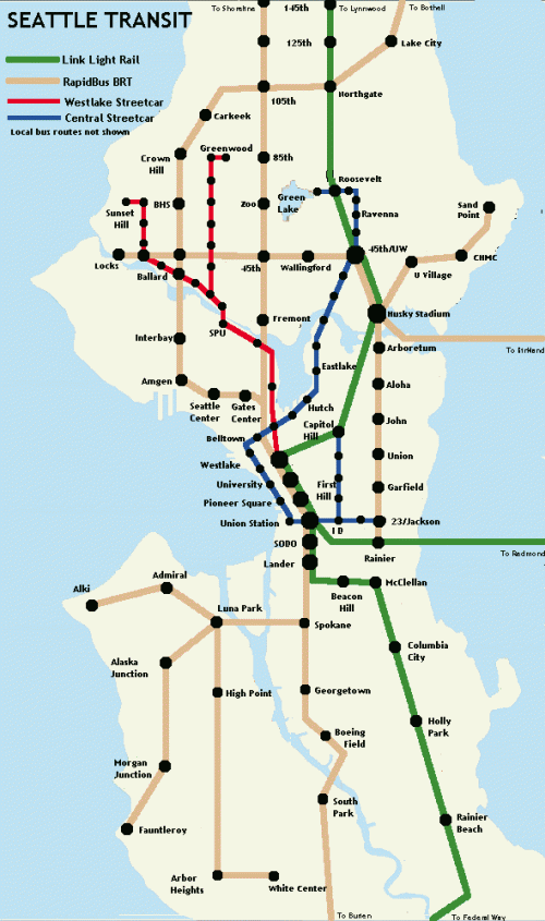
The streetcar network expands to nearly 18 miles, with the South Lake Union streetcar extending north along Westlake to Ballard and Greenwood. The Waterfront streetcar extends north along Broad to Eastlake, Ravenna & Green Lake, and down Jackson and Broadway to First Hill and the CD.
The RapidBus network expands substantially. The plan shown calls for 30 miles beyond what is currently in the works. While BRT does not match the experience of rail, it can provide far superior service to traditional buses. Major arterials like Aurora and 15th NW get bus lanes, all routes get signal preemption, stops are spaced out further and substantial shelters with bus time displays are added.
And most important of all, there is service every 10 minutes, 7 days a week. The most frustrating part of the bus experience is the waiting. And as the popularity of the new RapidBus routes increases, the possibility of conversion to streetcar does too.
I invite comment and feedback on this map of the future. I hope we can realize the vision of a functional rapid transit network. Eighteen miles of streetcar and thirty miles of RapidBus lines to replace long-haul Metro routes is not anything Seattle can’t afford or achieve. That’s about $500 million for the streetcars, and $20 -$40 million for the BRT. Much less than the monorail, and much less than some have proposed to spend on a mile of tunnel.
The only thing we seem to lack is political will. To the politicians:
”Make no little plans; they have no magic to stir men’s blood”
– Daniel Burnham, architect – 1893 Worlds Fair

My concern is that most of this transit is “at grade”, meaning that transit will have to compete with cars and obey traffic signs and signals. This will make future transit, like our transit system now cumbersome and very slow. I believe we need transit “off grade” meaning either below in the form of tunnels or above using overpasses or pillars. Would these options be more expensive? most definitely but imagine a transit option that will take a rider from, for example, Lake City to SeaTac Airport in the same time or faster than taking a car. With traffic and parking becoming more and more diffucult, transit can become very attractive indeed.
You’re right about the indecipherable metro map; right about ‘core’ routes clearly delineated from milk runs and connecting bus lines. Your maps lack detail. ‘Line-&-Dot’ maps are horrible.
You’re only proposing these routes and broad consensus is necessary for them to be seen as preferred. The lack of detail shows you haven’t incorporated all options. Ultimately, you’ve got to incorporate all bus lines that will become ‘feeder lines’ to LRT, BRT, other major bus routes and streetcar lines. Still, your initial integration is outstanding. I would wish you luck, but you’re gonna need more than that.
I’m just coming at the situation from the realistic assumption that the tunnel to Roosevelt is going to suck up all of Sound Transit’s cash until 2025 (and probably beyond). We had our chance for grade seperated transit in the city, and its gone.
I’m working on better maps, but most of the routes I proposed are official. The Eastlake, ID & Broadway streetcar lines are official proposals. The 15th NW, West Seattle and 520 BRT lines too, I’ve just extrapolated logical extensions.
BRT won’t work on chokepoints like the West Seattle Bridge’s Delridge Way onramp intersection, where cars must cross over the dedicated bus lane to get to the lane for SR99, or to the lanes for I-5. Another chokepoint is the 1st Av. exit on the Spokane St. Viaduct. Traffic backs up so far on the viaduct and bridge that it’s impossible for buses to maintain a time reliable schedule on West Seattle-Downtown routes. No one has come up with any ways to get around this type of chokepoint. That’s why grade separated transit is preferrable.
ford houston southern